Few countries in the world are as deeply shaped by the sea as Denmark.
From wind-swept dunes and fishing villages on the North Sea to white-sand beaches along the Baltic, the Danish landscape is defined by its incredible coastline – one of the longest in Europe compared to the nation’s modest size.
But how long is Denmark’s coastline exactly? And why is it so extensive? Let’s explore the numbers, geography, and fascinating facts behind this maritime nation.
How Long Is Denmark’s Coastline?
According to Statistics Denmark and the Danish Geodata Agency, the total coastline of Denmark (excluding Greenland and the Faroe Islands) measures 8,750 kilometers, which equals roughly 5,435 miles.
When Greenland and the Faroe Islands are included – both being autonomous territories within the Kingdom of Denmark – the total coastline skyrockets to over 44,000 kilometers (27,340 miles).
This immense length is primarily due to Greenland’s rugged and deeply indented shores.
So, in summary:
- Mainland Denmark coastline length: ~8,750 km (5,435 miles)
- Total Kingdom of Denmark coastline (with Greenland): ~44,000 km (27,340 miles)
This vast stretch of shoreline gives Denmark one of the longest coastlines in the world relative to its land area.

Why Denmark Has Such a Long Coastline
At first glance, Denmark might seem small – it covers only around 43,000 square kilometers of land. Yet, the country’s geography is extraordinarily fragmented.
The nation is composed of the Jutland Peninsula and an archipelago of more than 400 named islands, about 70 of which are inhabited.
Each island adds its own bays, fjords, and inlets, dramatically increasing the overall coastline.
This is a classic case of the “coastline paradox,” where the more detailed you measure the edges, the longer the total becomes.
Another reason for Denmark’s extensive shoreline is its glacial history.
During the Ice Age, glaciers carved out valleys and fjords, later flooded by rising sea levels.
The result is an intricate, irregular landscape that twists and curves in every direction – perfect for sailors, but a nightmare for anyone trying to measure it precisely.
Denmark’s Geography and Coastline
Denmark lies between the North Sea and the Baltic Sea, bordered by Germany to the south and connected to Sweden via the Øresund Bridge.
This location gives the country two distinct maritime faces:
- The North Sea coast is wild and rugged, shaped by strong winds and powerful waves.
- The Baltic Sea coast is calmer, dotted with sandy beaches and gentle bays.
The Jutland Peninsula (Jylland) forms the mainland, stretching up toward Skagen, where the two seas meet dramatically – you can literally stand with one foot in each sea at Grenen.
The islands of Zealand (Sjælland), Funen (Fyn), and Bornholm are among the largest and most well-known, while hundreds of smaller islands – such as Lolland, Falster, Ærø, and Læsø — contribute to Denmark’s intricate shoreline.

The Number of Islands in Denmark
The Danish Archipelago is central to understanding why the coastline is so long. Denmark officially has over 400 islands, although some estimates reach closer to 500 when counting very small or tidal islets. Of these, around 70 are inhabited.
The constant presence of islands – large and small – dramatically increases the total shoreline. Imagine tracing the outline of each one; even the tiniest skerries and islets add valuable kilometers to the national total.
Some of the most famous Danish islands include:
- Zealand (Sjælland) – home to Copenhagen
- Funen (Fyn) – linked to both Zealand and Jutland by bridges
- Bornholm – located in the Baltic Sea near Sweden
- Langeland – known for its beautiful beaches and cliffs
- Ærø – a favorite among sailors and tourists
Greenland’s Coastline and Its Impact on the Total
While mainland Denmark already has an impressive shoreline, Greenland’s coastline takes things to another level.
The Arctic island’s jagged, glacier-carved perimeter measures approximately 44,087 kilometers (27,385 miles) — about five times longer than the entire coast of continental Denmark.
If you combine these figures, the Kingdom of Denmark ranks among the countries with the longest total coastlines in the world, rivaling nations like Canada and Norway.
Greenland’s coastline is so extensive because it is heavily indented by fjords, inlets, and ice-carved bays, many of which are only accessible by boat or helicopter.
For a closer look, the National Museum of Greenland and Visit Greenland offer fascinating insights into its geography and maritime culture.
Denmark’s Maritime Borders
The Danish coastline is not just long — it’s also strategically positioned. Denmark has sea borders with:
- Sweden across the Øresund Strait
- Norway across the Skagerrak
- Germany through the Flensburg Fjord and the Baltic Sea
The Danish straits – Øresund, Storebælt, and Lillebælt – form vital shipping lanes connecting the North Sea and the Baltic Sea, making Denmark a key maritime gateway in Northern Europe.
These waterways have shaped Denmark’s economy, culture, and history for centuries, from Viking trade routes to modern shipping and wind energy industries.
Interesting Facts About Denmark’s Coastline
- No Dane lives far from the sea. The furthest point from the coast in Denmark is only about 52 kilometers (32 miles) away.
- Countless beaches. There are over 1,000 public beaches across the country, many of them Blue Flag certified for cleanliness.
- Protected nature. Large stretches of the coast are part of national parks and nature reserves, such as Thy National Park and Mols Bjerge.
- Maritime heritage. The sea has been central to Danish life for centuries — from Viking shipbuilding to today’s world-leading offshore wind farms.
- Erosion and conservation. Coastal erosion is a growing issue, particularly along the North Sea. Projects like those by Kystdirektoratet aim to protect vulnerable shorelines.
Denmark’s Coastline Compared to Other Countries
When compared to other European nations, Denmark’s coastline is remarkably long for its size.
| Country | Coastline (km) | Land Area (km²) | Coastline/Land Ratio |
|---|---|---|---|
| Denmark | ~8,750 | 43,000 | 0.20 |
| Norway | ~25,000 | 385,000 | 0.06 |
| United Kingdom | ~12,400 | 243,000 | 0.05 |
| Germany | ~2,400 | 357,000 | 0.006 |
This high ratio shows how intricately Denmark is intertwined with the sea. It’s not just a land surrounded by water – it’s a maritime nation in every sense.
Denmark’s Coastal Landscape and Nature
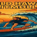
The Danish coastline is incredibly varied. The west coast of Jutland faces the raw power of the North Sea, featuring tall dunes, wide beaches, and constant winds that make it a haven for surfers – especially in Klitmøller, known as Cold Hawaii.
The east coast, facing the Baltic, offers gentler scenery — shallow bays, green fields, and historic harbor towns like Ebeltoft and Kerteminde.
Many of these areas are perfect for kayaking, cycling, and coastal hiking.
The diversity of Denmark’s coasts has also inspired environmental protection. Over 10% of Denmark’s total area is classified as coastal or marine protected zones, supporting wildlife such as seals, porpoises, and migratory birds.
Why Denmark’s Coastline Matters
Denmark’s long coastline has defined its identity – economically, culturally, and environmentally.
Fishing, shipbuilding, and trade shaped the country’s development for centuries, while the modern era has seen Denmark become a leader in sustainable ocean management and offshore wind energy.
Tourism also thrives along the coast, from beach holidays in Blokhus to island retreats on Ærø. The shorelines continue to connect Danes to nature, offering a sense of freedom and openness that reflects the national spirit.
A Small Country with a Huge Coast
So, how long is Denmark’s coastline? Roughly 8,750 kilometers (5,435 miles) without Greenland, and over 44,000 kilometers (27,340 miles) when including it.
That’s an extraordinary number for a small Northern European country – a testament to its islands, fjords, and glacially carved terrain.
From the wild waves of the North Sea to the calm bays of the Baltic, Denmark’s coast defines its geography, lifestyle, and identity.
It’s fair to say: in Denmark, the sea is never far away.